Live debate to discuss how the final experiments work on flat earth. The YouTube live was scheduled for August 23rd. All Flat Earthers who attended were Senior Flat Earth Researchers who believed in the 24hr Sun in Union Glacier Camp. This includes Awake Souls (Ronnie and Jason), and Lindsay Harris from Tomb of Illumination. The end included some trolls. The Final Debate was over three hours but you can learn why all 12 of the experiments work fine on Flat Earth from the video below it.
What are The Final Experiments?
- Equatorial Mounts https://www.youtube.com/watch?v=TbCrQb-qWeE
- Distance Between Meridians https://www.youtube.com/watch?v=PJ2kli-ABNM
- Weight Variation https://www.youtube.com/watch?v=2peNwyC7MaU
- Crossing Antartica https://www.youtube.com/watch?v=XqYcIYQSbdk&pp=0gcJCa0JAYcqIYzv
- Shadow Predictions https://www.youtube.com/watch?v=9comYMcMcio&t=878s&pp=0gcJCa0JAYcqIYzv
- South Pole Flights https://www.youtube.com/watch?v=4y6QZLDAeXk
- Southern Hemisphere Flights https://www.youtube.com/watch?v=W3w1voXWgu0&pp=0gcJCa0JAYcqIYzv
- The South Pole https://www.youtube.com/watch?v=4FblzXj3q4s&pp=0gcJCa0JAYcqIYzv
- Sunrise & Sunset Direction https://www.youtube.com/watch?v=_2Wy2aTnTME&t=878s
- South Celestial Pole https://www.youtube.com/watch?v=5Ih7NvUYg4g&t=1s
- 24hr Moon in Antartica https://www.youtube.com/watch?v=XcLSzLbu-vE&t=137s
- 24hr Sun in Antartica https://www.youtube.com/watch?v=1kjnj_34YaM
What needs further research? Conclusion from Dr. Alonzo
In Dr. Alonzo’s opinion only section 2, 6, and 7 require further research and can be given a yellow rating for danger at the current moment. None of these are red flags for the Flat Earth model as there are theoretical concepts which allow for it. If we accept section 2 “Distance Between Meridians” as true, this means the Flat Earth measures into a globe despite being flat, meaning that for section 6 and 7 we have to account for that with Lorentz Ether Length Transformations which is speculative at this stage of academic research. Dr. Alonzo believes a Lorentz Ether Length Transformation is also the best approach when we are not contesting the data and the assumption is that flight paths, duration, and times are correct. Meaning that from the extreme example, walking around the edge of the Firmament is the same relative speed as walking around North Pole.
These would be considered the only “yellow flags” in the academic consensus after reviewing how all 12 of The Final Experiments not only validate, but fit within the Flat Earth model. There are no red flags found. Most of the experiments such as 24hr Sun or Moon are green flags as the Flat Earth model requires them.
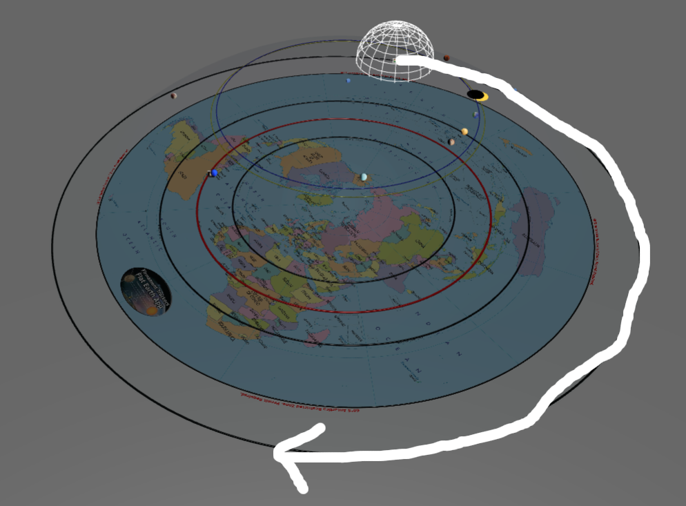
GPS Tracking from The Final Experiment
https://z6z.co/thefinalexperiment
1) Equatorial Mount
Best place to learn about these mini domes is in Stellarium. This is trusted by globers so it allows you to introduce unknown concepts to them easier. Since globe models don’t allow for multiple observers, and only support single observers, they can often be confused the first time they come across Flat Earth models which do support multiple observers, and in this case we can use the Dr. Marsh Globe Model to show the 3rd person view that Stellarium does not allow.
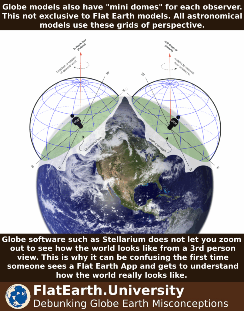
Then it’s important to understand how this is just a flat earth projection onto the globe model. Because a local tangent is flat but the globe is curved, it’s impossible to make it fit; unlike how in the more realistic Flat Earth model, it lays flat and touches the ground.
2) Distance Between Meridians
The Flat Earth does measure the same distances of a globe model despite being flat. This lets us conclude that the two models must be reversed engineered from each other. Whichever one is real, the other was reverse engineered from it.
3) Weight Variation
Gauss’ Law of Gravity allows us to discover the gravitational field due to an infinite flat plane of mass. Because Gauss’ Law of Gravity is derived directly from Newton’s law, this is not debatable and must be accepted by anyone approaching the discussion in good faith.
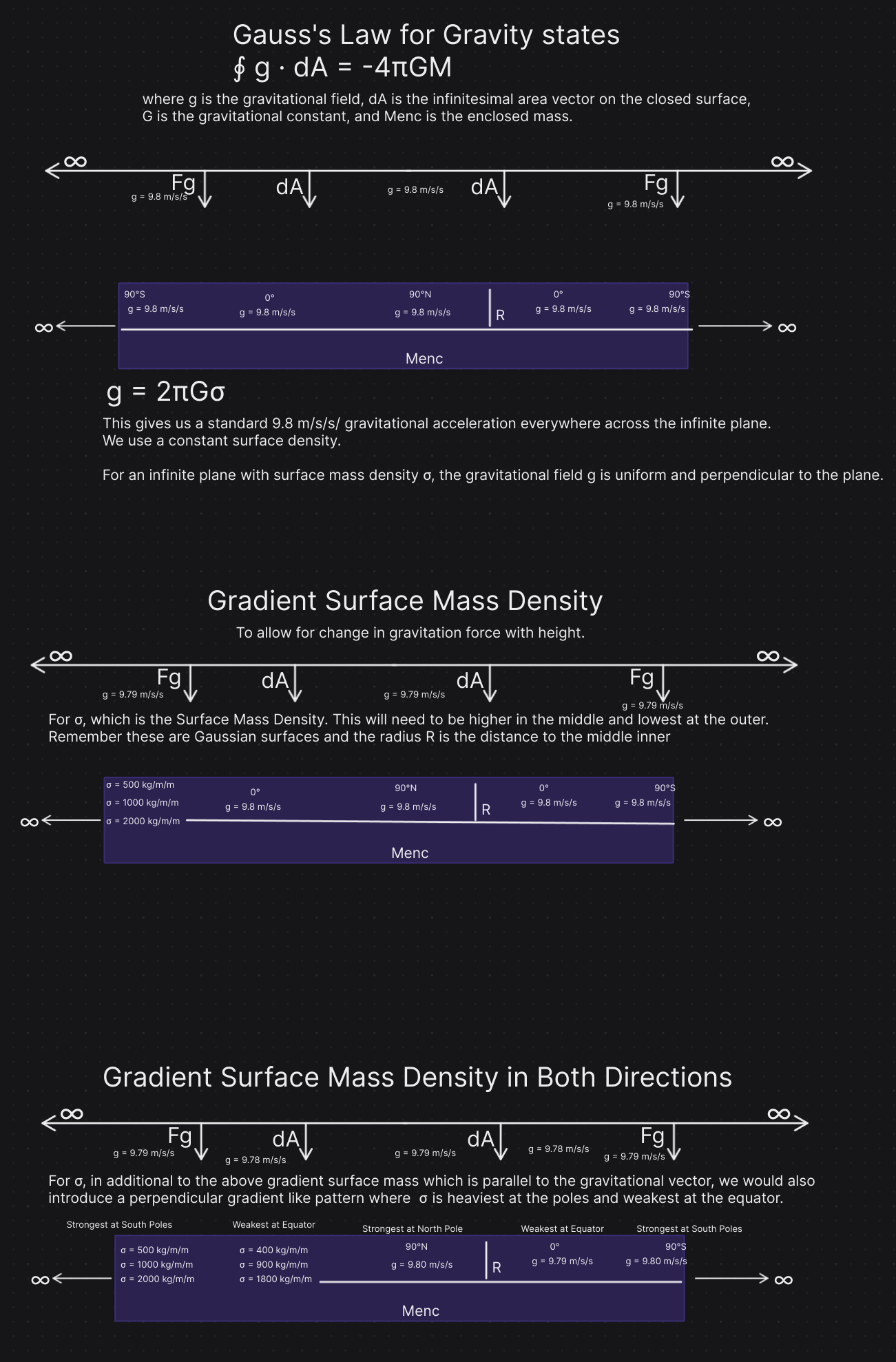
So that we can have a gravitational force that decreases with height and is strongest at the poles and weakest the equator, matching the WGS84 predictions of height from a globe which becomes directly proportional to:
Vertical gradient in surface mass density (σ) to make gravity decrease with altitude.
Lateral gradient (across the plane) where: σ is strongest at the poles, weakest at the equator.
Proportionality because the actual gradient surface mass density doesn’t need to be measured nor known to show the relationship and the proof of concept. Remember this is a valid physical modeling approach. Many theoretical models in physics start with “scaling laws” or proportional relationships before moving to measurable constants. Our goal is just to show it works perfectly fine within the Flat Earth model.
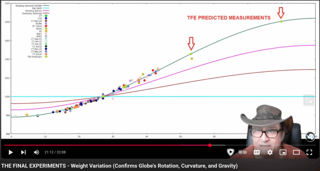
Showing that the teal line used for “flat earth” only represents the gravity denying group. Many Flat Earthers do deny gravity and it’s sad. For them they have no model, cannot make any claims, and cannot make any predispositions. As Senior Flat Earth Researchers we know that the Force of Gravity can be measured objectively in real life and we know that the Flat Earth model requires it through Gauss’ Law of Gravity. We also know that Earth must rest upon an infinite plane since the gravitational vectors observered in real life so point the ground and not to the center of a floating disc in space.

This is how the universe looks in real life. The Gleason Map (North Polar AE) which is what we call “Earth” is finite and has fixed dimensions we know since latitude is not debated nor distorted. Earth rests upon an infinite plane which I call the universe.
| Model | Cause of Weight Change |
|---|
| Globe | Rotation + spherical shape (radius variation) |
| Flat Earth | Vertical + lateral gradient in surface mass density (σ) |
4) Crossing Antarctica
No one ever crosses directly due South on the compass. Instead they go off angle slightly. For example on your compass South is going to be labeled at 180 degrees, so instead, all you do is actually go 179.99 degrees or 180.01 degrees which will allow you wrap around the Firmament.
Understanding that is based on the assumption they even did what they claimed. They could be lying. There may be land beyond the poles.
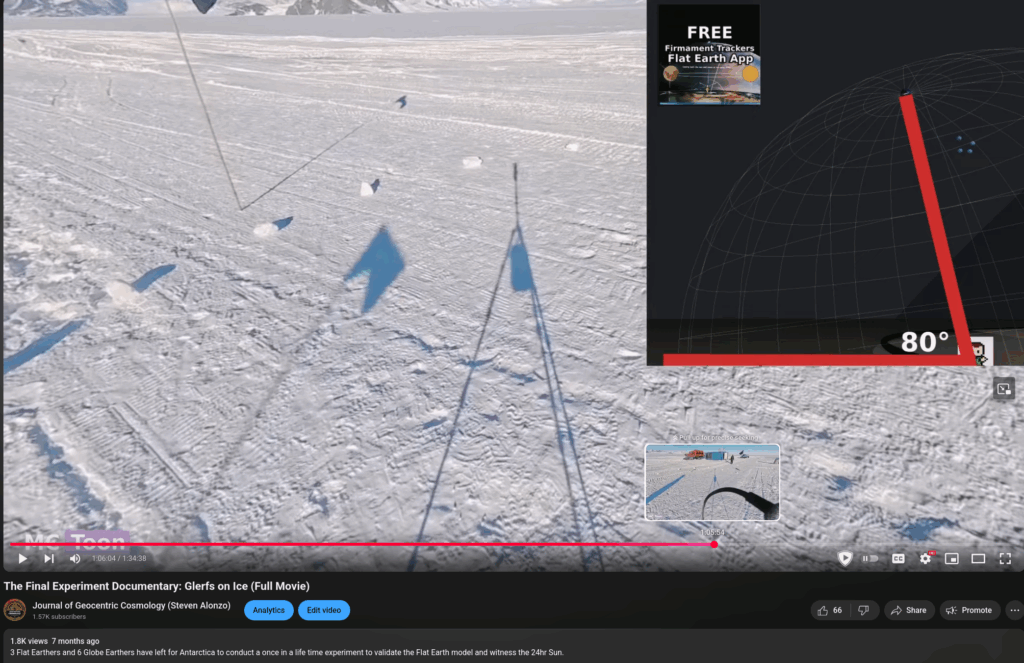
5) Shadow Predictions
Teaching someone how a sundial works after they learned about the Equatorial Grid allows the concept to make perfect sense. The sundial stick is pointed towards either the North Celestial Pole or the South Celestial Poles. The sun moves around the Equatorial Grid. Radius of EQ grid / stick is arbitrary size.
This also matches McToon’s shadow predictions from The Final Experiment. At Union Glacier we would point our sundial stick 80 degrees since our latitude is 80 degrees and the south celestial pole is 80 degrees. These 1:1 ratios and right angle triangles are also good indicator that we live on a flat earth.
6) South Pole Flights
This would fall under section 4) Crossing Antarctica assuming we are not talking about south pole flight times or distances which would fall under section 7) Southern Hemisphere Flights which is below:
7) Southern Hemisphere Flights
8) The South Pole
Globers tend to use this as a way to combine magnetic poles, geographic poles, and celestial poles. Establish the clear difference between all three.
Magnetic Poles: Related to the magnetic force only. Flat Earth has a radial magnetic field with one magnetic north pole and an infinite south magnetic poles.
Geographic Poles: Physical matter. This has to do with the surface you live on. Important to remember that longitude is an infinite coordinate system we know that a south geographic pole cannot actually exist at -90 latitude south and therefore the longitude begins to matter on Flat Earth.
On the Firmament Trackers Flat Earth Model we discovered that the Geographic South pole is located at Longitude -139. This would be south-east of New Zealand and south-west of north america.
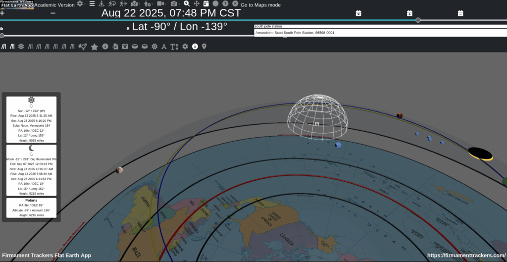
This is why it is so important to use uncensored tools unlike Google Maps that won’t let you discover the true locations of places. The Firmament Trackers Flat Earth Model has a custom mapping platform in the Academic Version. It’s like Google Maps but for Flat Earth.
Celestial Poles: Visual only. This has to do with what you see. This is discussed in section 10 below.
9) Sunrise & Sunset Direction
Very simple application of the Equatorial Grid. You can see in the photos below the left image shows the sunrise and right image shows the sunset. Notice where the South Celestial Pole is and the angle it’s aligned? You can visually imagine what would happen if you pushed it down more, the sun would no longer be visible. The math is very simple since it’s a 1:1 ration of latitude to celestial declination. Move 10 degrees South. This EQ grid is lowered 10 degrees. Likewise we also know the location of the sun (celestial declination 23) and the observers latitude around 53 degrees so we know the offset of the EQ grid.
10) South Celestial Pole
Very simple to understand since longitude is a continuous coordinate system we therefore have an infinite amount of south celestial poles.
11) 24hr Moon in Antarctica
Works the same as every other celestial object.
12) 24hr Sun in Antarctica
Works the same as every other celestial object. Easiest to measure and predict since the Sun follows the exact same pattern every year. A celestial declination range of 23 to -23. So in December we know the Ground Position (physical latitude and longitude that the Sun is directly above). This allows us to easily confirm against any latitude whether or not it will be visible for 24hrs. This is how we knew for certain prior to TFE that the Flat Earth model requires and predicts this 24hr Sun. To clarify, TFE can be entirely fake, and the Flat Earth model will still require and predict the 24hr Sun in Union Glacier. The math and science is how we know of this.